| Mangamahu Lahars |

|
|---|
Lahars
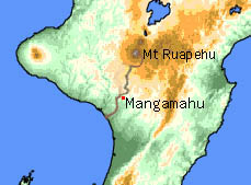
The Mangamahu river flats have been built up by lahars from the crater lake of Mt Ruapehu flowing down our sulphurous Whangaehu River.
When I
was going to Mangamahu School in 1948, the County Council had a gravel-pit
where the Mangamahu Creek flowed into the Whangaehu River, and as it
removed the gravel, the Council front-end loader dug out old tree trunks
and a clay layer with fossil fern leaves in them. And as we walked to
school up the hill to the school flat, we scratched our initials in
the different layers of sand and silt and gravel. One layer seemed to
have worm holes in it.
Recently I came across an article about those layers of gravel and ancient
topsoils in a nearby Mangamahu metal pit near the top end of the Rush
Flat. (1972, I B Campbell, Recent aggredation in Whangehu Valley,
NZ J Geol Geoph)
I had to wade through a lot of jargon, like paleosol for ancient
buried topsoil, and colluvium for old landslips, but basically
it shows that ......
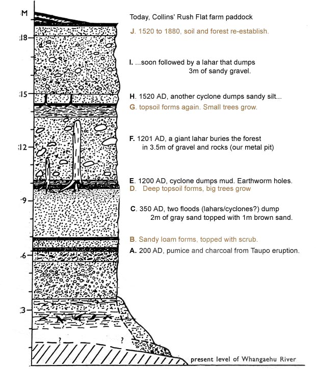
A. In about 200 AD, just after the big Taupo eruption, a lahar deposited
a layer of sand, mixed with pumice and charcoal, at 6 metres above present
river level.
B. On top of that, a sandy loam formed with a bit of scrubby 2nd growth
that would have taken perhaps 150 years to form.
C. In about 350 AD one or two lahars dumped a three-metre-deep layer
of sand that now lies in a layer from 7 to 10 metres above the river.
D. For the next 900 years, a really good topsoil built up on this sand
(at the level of the County Council metal pit - 10m) with big forest
earthworms making holes that you can still see in there. And a totara
forest grew above this topsoil, with some of the trees being perhaps
700 years old.
There were probably some big floods around 750 and 950 AD, but none
reached the 10 metre mark as the river channel had probably flushed
itself clear.
E. Around 1200 AD, the Mediaeval Maximum started to develop. It was
the warmest period in 2000 years: Greenland and New Zealand both underwent
large-scale colonisation as a result. The raised temperature evaporated
lots of extra water out of the Pacific Ocean, spawning a cyclone that
produced a flood which left silt all through the floor of our 900 year
old forest, at the 10.5 metre level.
F. The silt had only just dried out when, weakened by the cyclone, the
wall of Ruapehu's crater lake broke, releasing a lahar that buried the
forest in a 3 metre layer of gravel and rocks (up to the 13.5 m level)
topped by a metre of silt.
G. For the next 300 years, 14.5 metres above the present river level,
the forest started to re-establish itself while ice built up on Ruapehu
during the chilly, dry Sporer Minimum.
H. Then around 1520, the Earth abruptly warmed up again, and the flood
from yet another cyclone choked the scrub with half a metre of sandy
silt (up to the 15m level) . . .
I. . . . and not long after, the crater lake burst again, starting a
lahar that dumped 3 metres of sandy gravel (up to the 18m level).
J. And the building process of soil-and-second-growth began all over
again for 360 years until about the 1880s when Henry Addenbrooke cleared
the forest for farming.
I guess that further clear-water floods dug out the river channel to
lower it to its original bed again.
Start
reading this diagram from the BOTTOM. 
This
is simplified from Campbell's original
profile.
Sunspots
When I
was a kid, and the Council first dug out those tree trunks and we found
fossil fern leaves. "Hey! Wow!" I enthused, "Real fossils
like in my Arthur
Mee's Children's Encyclopedia! Millions of years old!" So I
was a bit disappointed when I first found Campbell's article.
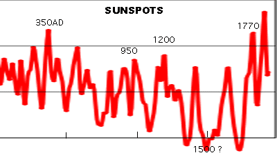
But in his article, he notes that rivers all over New Zealand have silted
up during the same eight time periods; 200AD, 350, 750,
950, 1200, 1500, 1770, 1950.
And these silting times correspond to eight periods of unusually warm
weather, found by counting wide and thin tree-rings, and isotope ratios
in Nelson limestone cave stalactites.

These eight
warm periods generally correspond to eight periods when there have been
lots more sunspots than in the usual 11 year sunspot cycle. Apparently
the sun's magnetic field changes slightly, so it releases more heat
and makes more spots.
The last active sunspot period started in 1950 and is just waning now.
Notice the Tangiwai lahar was in 1953, and cyclone Bola, etc.
So those lines in the roadside cuttings below the Mangamahu School are
really a record of magnetic changes in the sun!