Waiouru in Ancient Times
1.
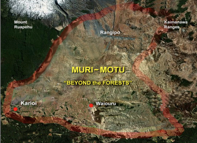
Waiouru is on the Murimotu plains
For Polynesians north of us, mo-tu ("where it's rising")
were islands rising up from the sea. Sailors could seek
shelter there. So in Aotearoa, patches of forest rising up
from bare land also became known as motu, where travellers
could find shelter and firewood. But the tussock and desert
lands around Waiouru were "muri motu," beyond the forests.
Coast-to-coast travellers could walk across them very
easily, but there was little shelter if the weather turned
cold and wet.
2. When Murimotu was under the
sea
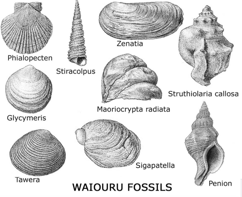
The
Murimotu plains were once under the sea. You can find about
25 different shellfish in the old seabeds that make up the
hills behind Waiouru. Here are some of the more common ones.
When you find one, look the name up in Google to discover
the age of the layer of hillside that you found it in.
By
identifying
the fossils that they find in a layer formed by an old
seabed, Geologists can tell when and where the layer was
formed. If you are still at Waiouru, happy hunting.
Between
200
to 150 million years ago mud and fine sand was carried down
rivers and into a deep sea bed and hardened to form
greywacke rock. That's the rock in the narrow gorges of the
Moawhango River.
Then between 70 to 50 million years ago, rivers flowing into
the sea from the Tararua Ranges deposited mud on top of this
to create mudstone, forming the soils in the lower cliffs of
Home Valley.
About 6 million years ago, sea beds around the New Zealand
landmass became shallower, and the resulting shallow coastal
waters in the Waiouru area supported enough shellfish to
produce calcium carbonate skeletons, the sea-shells you find
on the hillsides.
The
Whanganui Basin then became deeper once again, and rivers
from the Kaimai Ranges deposited mica sediments on top of
the sea shell layer.
Finally, about 3 million years ago, this filled-in coastal
basin began to be lifted up again.
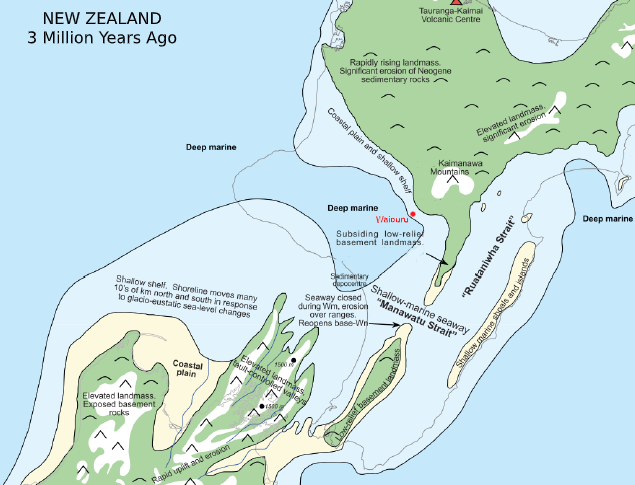
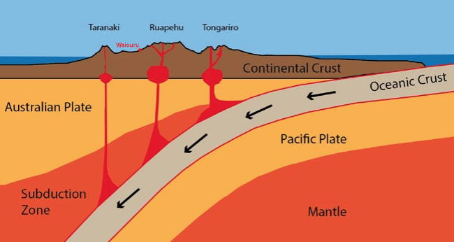
Today Waiouru is 900 metres above sea level, lifted up by
the Pacific plate of the Earth's crust sliding under the
Australian plate, pushing it up and creating lots of
earthquakes and volcanic eruptions while doing so.
Mt Ruapehu erupts about one year in every 25 years.
3. Murimotu's earthquake fault lines
Big
quakes have also shaped the Waiouru hills. The GNS Science
website map gives the red lines below as "active
faultlines," although they move only once every 2000
years or so.
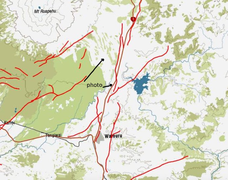
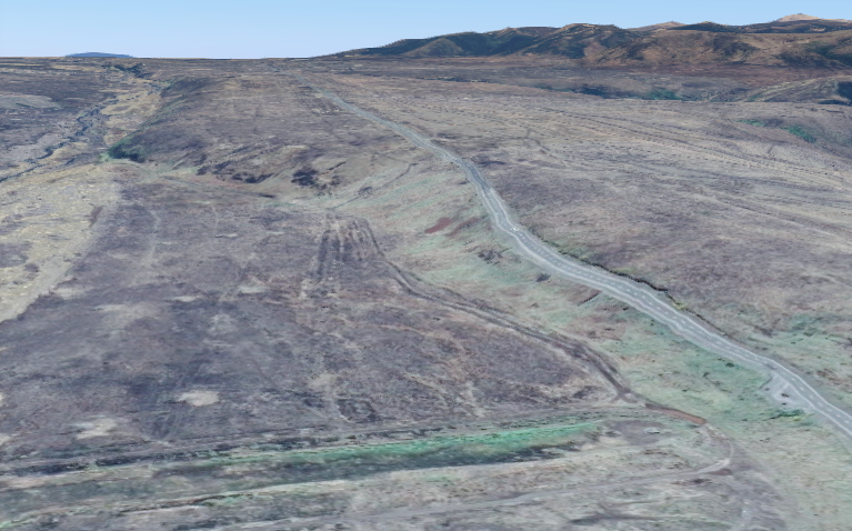
The faultline running up the western side of the long
straight on the Desert Road (brown line) is the most
obvious one today. When you drive up the hill past the
entrance to Lake Mowhango, you are going up that fault
line.
4. Lahars have formed the plains around the
volcanoes
Lahars
have
createded the Murimotu plains west of
Waiouru. Water collects in the Ruapehu
crater lake from rain and melting snow,
and when the mountain erupts, or when the
lake's ice wall melts, a muddy flow pours
down the mountainside. There have been
hundreds of small lahars in the last
thousand years, but carbon dating shows
that the river flats lower down the
Whangaehu River were built up to their
present levels by mega-lahars coming past
Waiouru during periods of global warming.
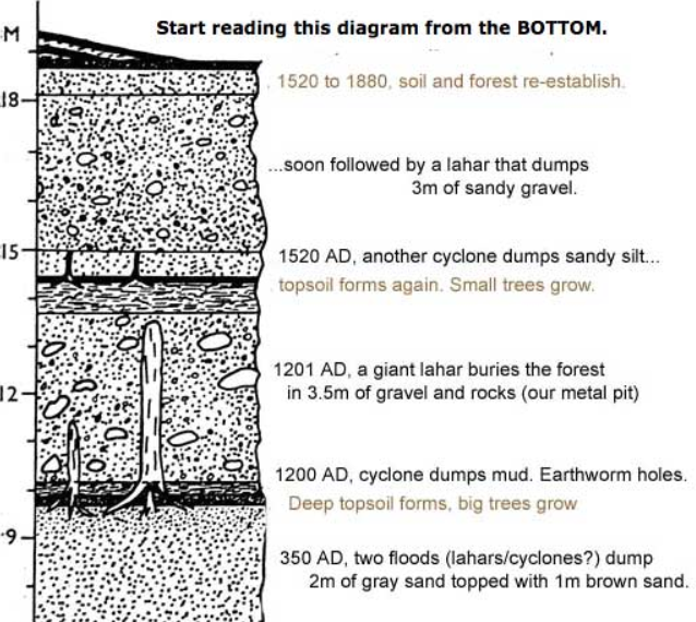
In
about 350 AD lahars dumped 3 metres of
volcanic sand on top of the white pumice
from the Taupo, and forests grew on them
for almost 900 years; big totara
trees were growing on the river flats of
the Whangaehu river valley.
Then came the "Medieval Maximum," the
warmest period in 2000 years: Greenland
and New Zealand both underwent large-scale
colonisation as a result (from Denmark and
Polynesia). The raised temperatures
evaporated lots of extra water out of the
Pacific Ocean, spawning a cyclone that
dumped water on Ruapehu and on the
Whangaehu hills, producing a flood that
left silt all through the floor of the 900
year old forest.
The
silt had only just dried out when,
weakened by the cyclone, the wall of
Ruapehu's crater lake broke, releasing an
enormous lahar that buried the forest in a
3 metre layer of gravel and rocks, topped
by a metre of silt, and smashed off the
tops of the totara trees. From about 1890
to 1960, this gravel layer was dug out for
metalling the clay roads in the Whangaehu
valley where I spent my childhood, and I
saw several of these battered tree trunks.
For the next 300 years, (15 metre level)
the forest started to re-establish itself
while ice built up on Ruapehu during a
chilly, dry period.
Then around 1520, the Earth abruptly
warmed up again for 50 years, and the
flood from yet another cyclone choked the
scrub with half a metre of sandy silt . .
. .
. . . . and not long after, the crater
lake burst again, creating one more huge
lahar that dumped yet another 3 metres of
sandy gravel on the flats. It would have
ruined any Ngati Awa kumara crops on them.
5.
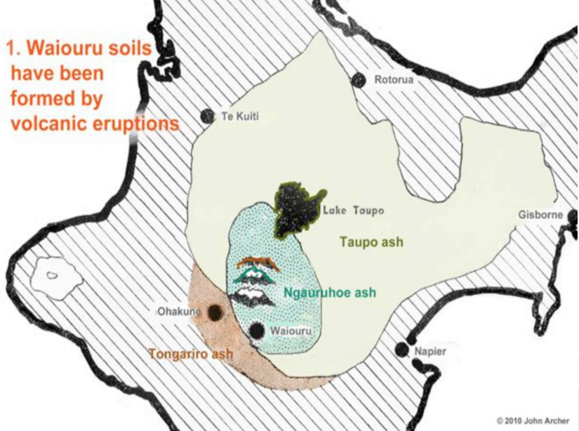
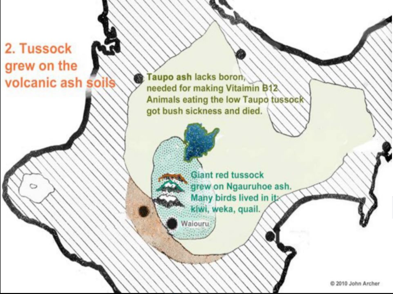
Murimotu's volcanic soils.
Waiouru
sits on a layer of dark volcanic ash recently
deposited by Mt Ngauruhoe. Just below it is a
shallow layer of white pumice with burnt logs in
it from the vast Taupo eruption in 183 AD. The
white pumice ash was about 1000 deg C and moving
at about 600kph. Beneath the white Taupo pumice is
rich brown ash soil laid down by an eruption from
Mt Tongariro in about 8000 BC. This rich brown
Tongariro ash is still the top layer for Karioi,
Ohakune, Raetihi; hence all the carrot growing in
this district.
You can identify these different layers when you
see them in road cuttings, ditches or gunpits.
These eruptions, and the different growth on each
of the soils they laid down, play a big part in
the stories of human settlement that follow.
6.
Birds on the Murimotu plains
The Ngauruhoe ash north of Waiouru was quickly
covered by giant red tussock which provided Moa
with leaves to graze on, and smaller
ground-walking birds like Kiwi,
Weka, tiny
Matuhi, and Koreke
(NZ quail)
with seeds, insects and worms, as well as tunnels
to shelter them from Eagles, Hawks,
rain, wind and snow.
Flying up from the Taranaki coast, Tītī
(mutton birds) dug tunnels (rua-titi) where they
could lay eggs and raise chicks, safe from
predatory hawks and gulls on the seashore. They
made many trips up from the sea with
bellies full of fish,
and the nitrogen, phosphorus and potassium in
their excretions stimulated plant growth.
Where patches of forests had survived the
nuclear-explosion-scale blast from Taupo, there
were Kakapo, Kereru
and Tui. But how many of these
birds have you seen or heard here? When Europeans
came, they brought large rats, dogs and stoats
that killed most of those birds.
Next
7.
Settlers arrive from Polynesia
|