|
This article was first
published (with the diagram only) in the Auckland-Waikato Historical
Journal No. 70 (September 1997), pp. 39-40. Copyright is the property of
Auckland Historical Society Inc. and the author.
ABSTRACT: This article reviews sixteen early portages in, or near to the
present-day Auckland region, and provides some details of the
communication system north and south of Auckland. Early Maori developed a
communication network that took advantage of natural geographical
features. The hub of the ancient communications system was the Waitemata
Harbour and although Governor Hobson declared he was influenced in his
selection of the site of Auckland by the great facility of internal water
communications, it was in fact Hobson's recognition that Maori had used
the network over a long period of time.
The author would like to point out that all the portages are easily
identified today and encourages Aucklanders, and visitors, to inspect
these interesting features.
Source unknown.
The abbreviation
SU beneath an image in pages of this web
site indicates that the source is unknown. Any information on the
origin would be appreciated so that I can correctly credit the item.
E-mail address Page VXJ1.
The purpose of this article is to review some of the facts concerning
early portages (toanga waka) in, near, and leading to the present-day
Auckland region. There are around Te Tamakimakaurau forms a natural
communications centre and without doubt the importance of the waterways
network was recognised soon after the first Māori settlers arrived in New
Zealand.
| |
|
 |
|
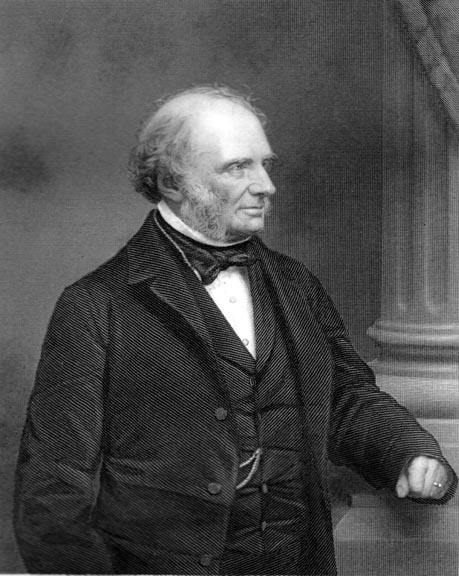
Mary Ann, Musgrave,
fl. 1821-1847.
"William Hobson",
1793-1842.
Watercolour |
|
Courtesy National
Library
of Australia. ( NK5277) |
| |
The early Tamaki lsthmus has been described as a natural Venice where
canoes must have been as numerous and as necessary as gondolas (Fisher,
1946, 49-57).
Not long after he landed in New Zealand, at the Bay of Islands, early in
1840, Governor William Hobson inspected the Waitemata area, and approved a
site for the proposed capital and settlement of Auckland. In a dispatch
from Government House, Russell, dated 15 October 1840, to the Secretary of
State for Colonies, Lord John Russell, Hobson included the following two
main reasons for his choice: ... I have been influenced ... first, by its
central position, secondly by the great facility of internal water
communications by the Kaipara and its branches to the northward; and the
Manakao [Manukau] and Waikato to the southward; (Holloway, 1962, 133).
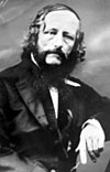
It was the missionary Henry Williams (1782-1867),
| |
 |
|
SU |
|
Henry
Wlliams. |
| |
who directed Hobson's attention to the Waitemata region as a suitable site
for the new capital; Williams had explored in the area in the early 1830s
(see Carlton, 1877, 167-74).
| |
 |
|
SU |
|
Lord John Russell -
British Colonial
Secretary at the time
of the founding of
New Zealand in 1840. |
| |
Before reviewing the list of portages it will be helpful
to mention briefly the ancient travelling routes in general use in, and
leading to Te Tamakimakaurau. Within the central part of the isthmus, land
tracks formed an important part of the communications network. Many of
these tracks, which extended mainly along the tops of ridges, developed
into roads after the start of European settlement. Parts of present-day St
Stephens Avenue, Parnell Road, Manukau Road, and Remuera Road, are
examples.
Main passages for north-south traffic existed on both sides of the
isthmus. The main inland communications system for the northern portion of
the North Island was determined by natural features in the west. From the
Waikato River, the short Waiuku portage brought voyagers to the Manukau
Harbour: and once Te Whau and the Ngongitepata portages were crossed,
voyagers were faced with a clear run north into the northern Wairoa River.
The second important northern passage ran parallel to the eastern
shoreline of the isthmus.
| |
|
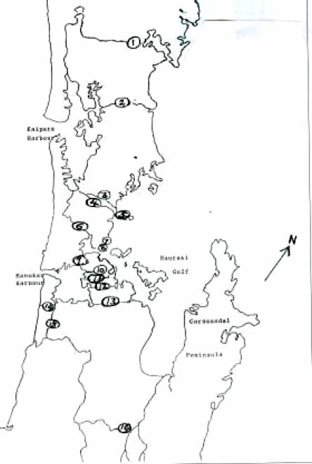 |
| |
|
BELOW: KEY TO THE MAP
OF AUCKLAND AND
VICINITY ABOVE SHOWING EARLY PORTAGES
1. (1) Mangapai Portage
2. (2) Otamatea portage
3. (3) Aotoetoe Portage
4. (4) Weiti Portage
5. (5) Waiau portage
6. (6) Ngongitepata (or Potoitoi) Portage
7. (7) Takapuna Portage
8. (9) Whau Portage
lO (10) Karetu Portage
11. (11) Otahuhu Portage (Te Tapotu 0 Tainui)
(12) Waokauri (or Pukaki) Portage
(13) Papakura portage
(14) Pokorud Portage
(15) Waiuku (or Te Pai o Kaiwaka) Portage
(16) Mangawara Portage
|
| |
People living in the Waikato and Waiuku districts, gained access to the
western side of the Hauraki Gulf, via the Manukau Harbour and by using any
one of three portages across the narrow part of the isthmus. All three
portages terminated at the Tamaki River. After voyaging down the Tamaki
River, northbound voyagers not wanting to cross to the west, proceeded
north off the east coast, hugging the land, and portaging again across the
Whangaparaoa Peninsula.
People living on or near the banks of the Waihou, Waitoa, and Piako
Rivers, or near the coasts on both sides of the Hauraki Gulf, joined the
northern waterways system via Tamaki Strait.
Since the eastern route off the coast was vulnerable to adverse weather
the river system was usually preferred, by north-south voyagers, to the
sea passage. To join the main western artery, north of the Waitemata
Harbour entrance, voyagers headed north. entered the mouth of the Weiti
River, then portaged from the Weiti River to the Kaukapakapa River. and
continued on to Kaipara Harbour.
The southern circular route, which included the Mangawara portage, enabled
Waikato people to reach the Waitemata Harbour by carrying their canoes
over only one portage if they desired or the circumstances were favourable.
William Colenso reported, in 1842, that Māori were able to voyage, aided
by short portages, nearly five hundred kilometres by rivers and sheltered
tidal waters from about Horahora on the Waikato River to around
Tangowahine on the northern Wairoa River (Taylor, 1959, I-57). The
Waikato, navigable by canoes for well over one hundred and sixty
kilometres from about Horahora, is joined by the Waipa, eighty kilometres
from its mouth. The Piako and Waihou were also each navigable for a
considerable distance.
Since war panties could appear from many different directions, the network
of waterways and port ages provided disadvantages as well as advantages
for people living in and near Te Tamaki makaurau.
The portages across the central pan of Te Tamakimakaurau were dominated by
three pa with a large population but the Whau portage was almost
completely removed from any large settlements.
Some of the port ages reviewed below are delineated in early maps; a list
of maps is provided in the appendix. The letters or letters following a
subheading link the portage to the relevant map or maps. The number
following a subheading relate to the portages shown in figure 1.
NB. The arrangement is north to south.
Mangapai Portage I
| |
 |
| |
|
Samuel Marsden
missionary and
recorder of early
Māori culture.
An early engraving. |
|
SU |
This portage extended from the Northern Wairoa River to Whangarei Harbour.
From Tangiteroria, the track reached to Maungakaramea and then to the
canoe landing at the head of the Mangapai River. Samuel Marsden
(1765-1838), who travelled over this route in 1820, mentions in his
journal that Hongi Hika conveyed war canoes over the portage (see Elder,
1932).
Otamatea Portage 2 C
This portage extended between Kaiwaka and Mangawhai; the Otamatea River
which flows into Kaipara Harbour joins the Kaiwaka River. William Colenso
(1811-99) travelled over this route in 1841 and reported the greatest
difficulty in finding his way through the thick vegetation (see
Taylor, 1959).
Aotoetoe Portage 3
The Aotoetoe Portage also allowed direct eastwest communication north of
Te Tamakimakaurau. By far the longest and most difficult portage in the
network, the Aotoetoe Portage was over fourteen kilometres in length. It
was probably seldom used but it is mentioned by S. Percy Smith in his book
Peopling of the North (Smith, 1896).
Weiti Portage 4
A portage between the Weiti and the Kaukapakapa Rivers effectively allowed
direct communication north of Te Tamakimakaurau, from the Pacific Ocean to
the Tasman Sea.
Waiau Portage 5
| |
 |
|
SU |
|
William
Colenso. |
| |
Probably a little-used portage but very useful at times the Waiau portage
existed across a low lying pan of Whangaparaoa Peninsula. Hongi Hika
probably carried his war canoes across this portage when he brought his
great fleet south to Te Tamakimakaurau, in 1821.
Visitors to the locality will find the line of the old portage extending
from the eastern end of Tindals Beach to Matakatia Bay. It is a
straightforward walk across the peninsula from one beach to the other;
the length is only about seven hundred metres.
Probably another portage existed across the neck of Whangaparaoa Peninsula
from Red Beach to the entrance to the Weiti River. A track is indicated in
Smith Elder's map of the Auckland district, 1852 (see Appendix, Map D).
Pongitepata (or Potoitoi) Portage (6)
Soon after they first settled in Te Tamakimakaurau Maori discovered that
it was virtually impossible to travel by land near the eastern shoreline
between Te Tamakimakaurau and the northern portion of the North lsland.
Too many rivers and cliff faces blocked the way. An eastern passage by sea
was possible but the preferred route to the north was via Kaipara Harbour.
Communication between the Waitemata and Kaipara Harbours, was effected by
portaging canoes from near Rangitopuni to the Kellmu River, which joins
the Kaipara River near Waimaukau. The Kaipara River flows into Kaipara
Harbour near Parakai. Northbound voyagers then navigated across Kaipara
Harbour, entered the mouth of the northern Wairoa River or one of the
other rivers that flow into the Kaipara, and then continued their journey
north or east. The large number of people who lived in the Kaipara area
also found this portage useful; it provided straightforward access to the
Manukau and Waitemata Harbours. Samuel Marsden was first escorted over
this route in July 1820 (see Elder, 1932).
The Ngongitepata Portage 6
This portage is easily identified today. The eastern end at Riverhead is
sign posted 'Kaipara Portage Road'. This area which was an important
junction in early times is readily accessible and well worth inspecting.
Takapuna Portage 7
The Takapuna Portage which linked the Hauraki Gulf with Shoal Bay was the
shortest of the portages in the Tamakimakaurau area.
Kukuwaka Portage 8
In early times a narrow neck of land existed between the northern end of
Karitai ( Narrow Neck Beach) and Ngataringa Bay. Not strictly a portage,
Kukuwaka allowed vessels to cross when tides were suitable. Kukuwaka means
'nip or scratch the canoe' (Graham, 1980, 16).
Whau Portage 9 C, D, E
The Whau Portage, slightly over three kilometres in length, connected the
upper Waitemata Harbour with the northern part of Manukau Harbour. This
low-lying portage was a very important link in the communications system.
In early times a number of headland pa near the Manukau Harbour controlled
the portage.
The Whau Portage is easily located today and is well worth a visit since
the entire length is accessible. Modern Portage Road follows the old track
from near Avondale Racecourse to Green Bay on the Manukau Harbour.
Visitors to the Green Bay end will notice the steep rise from the beach to
the road.
Karetu Portage 10
The Karetu Portage linked Anns Creek with Karetu, south of Panmure Basin.
The name Karetu is now unknown in the area and it is difficult to identify
the exact eastern end of the portage. Present-day Bowden Road probably
follows part of the eastern portion of the old track.
Almost twice as long as Otahuhu Portage, Karetu Portage was not as
elevated, Both the Karetu Portage and the Otahuhu Portage were within a
few hundred metres of Otahuhu pa and about the same distance from
Motukaroa and Ingoa-Kore; thus these portages were closely observed by
nearby people.
Karetu, on the Tamaki River, must have been a bustling landing point until
the 1840s; the location was proposed as the eastern terminal for the
KaretuOnehunga railway line planned by Felton Mathew. (See Brian Hooker,
1987 - Page NAU2 this web site - go via Contents above.)
Otahuhu portage (Te Tapotu o Tainui) 11 B, C,D,E
Twelve hundred metres south of the Karetu Portage the Otahuhu portage was
the most important in the immediate Tamakimakaurau area because of its
central position, length, and easy gradient, Slightly under one kilometre
in length it was the shortest portage between the east and west coasts of
New Zealand. And it was one of the main links in the communication network
between the northern and central districts of the North Island.
Present-day Portage Road, Otahuhu, follows approximately the line of the
old portage. The Manukau Harbour end is named Te Tapoi.
Tainui (i.e Tainui's arrival at the bottom of the portage slope). Also at
the Manukau Harbour end is Ngarango e rua o Tainui. which is the name
given jointly) to two small islands in Manukau Harbour, and according to
legend. is said to be the final resting place of Tainui's skids which had
been used to haul her across the portage.
|
|
 |
|
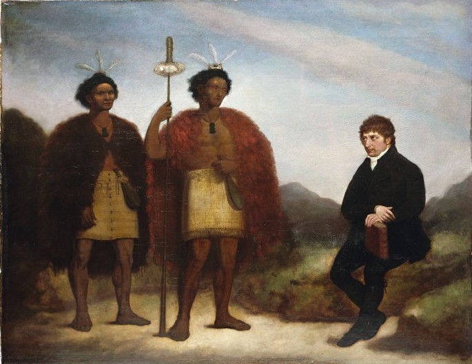
James Barry
"The Rev Thomas
Kendall and the Maori chiefs Hongi and Waikato, 1820 Hongi Hika with
Thomas Kendall".
Hongi was very
familiar with the northern portages and led his expeditions
overland. oil on canvas
The following notes have been
abbreviated from extensive text on the Alexander Turnbull
Library web site:
Waikato on the left,
Hongi Hika in the
centre, both standing and wearing kiwi feather cloaks and flax
skirts, both carrying mere and Hongi with taiaha as well. The
Reverend Thomas Kendall is seated on the right James Barry was
a lay member of
the C.M.S., and treasurer of its Durham Office, 1833-1846. He was
commissioned by the Society to paint this portrait. Painted in
London during the visit of Hongi Hika, Ngapuhi leader, and Waikato,
a younger Ngapuhi leader, accompanied by the Rev Thomas Kendall,
C.M.S. missionary in New Zealand. |
|
Permission of the Alexander Turnbull Library
must be obtained before any re-use
of this image. [G-618]
(The border is an
addition by the editor.) |
|
In 1822, when he was on his way to seize the triple pa of Matakitaki on
the Waipa River, Hongi Hika (c.1780-1828) dragged his canoes over
the Otahuhu Portage to theManukau Harbour (see Holloway, 1962,
76-77). Henry Williams, who visited the Otahuhu area, in 1835, described
the portage in his journal thus: " ... the appearance of a cart track
which has been formed by a number of canoes which have been drawn over
from time to time". (Carlton. 1877, 171).
Waokauri (or Pukaki) Portage 12 C, D
The third portage across the central isthmus existed to the south of
Otahuhu. The Waokauri (or Pukaki) Portage often eliminated the need for
voyagers to pass around Mangere Peninsula. In a present-day map this
portage can be traced from the location of the Middlemore-Grange Golf
Course, along Portage Road, Papatoetoe, to the eastern arm of Waokauri
Creek.
Papakura Portage (13) C
This portage extended from the area of present-day Papakura town to the
Wairoa River. Most likely Old Wairoa Road marked on modern maps is the
track followed by the earlier portage.
Pokorua Portage 14
This portage provided direct access to the Tasman Sea from the Waiuku
River via Lake Pokorua. The portage allowed canoes to leave Manukau
Harbour, visit the Toheroa beds at Murawai. and re-enter the harbour
without passing through the harbour entrance.
Waiuku (or Te Pai 0 Kaiwaka) Portage (15)
The Waiuku, or Te Pai 0 Kaiwaka Portage was an important path across the
narrow stretch of land between the Waiuku River and the Awaroa Stream
which is a tributary of the Waikato River. People reaching the Manukau
Harbour and heading south. entered the Waiuku River, hauled their vessels
over the portage to Purapura on the Awaroa Stream, and from there, gained
access to the Waikato River and its tributaries, the Waipa. and the
Mangawara, as well as tributaries of these rivers.
In 1842, Charles Terry. described the Waiuku Portage as 'a distance of
2,260 yards by the measurement of Captain W.E. Symonds, Deputy
Surveyor-General' (Terry, 1842, 39). A.S. Thomson mentioned in 1859,
warriors from the north were blocked from reaching the Waikato River by
the damming of the Awaroa Stream (Thomson, 1859,469).
Mangawara Portage 16 D
This portage enabled canoes to be carried or dragged between Mangawara
Stream, a tributary of the Waikato River, and the Piako River a distance
of about six kilometres. The route can be traced on a modern road map of
the south Auckland area, from Hoeotainui to Tahuna. Thus, in early times a
war party, in canoes, heading south from Manukau Harbour could appear a
few days later in the Hauraki Gulf or the Waitemata Harbour without having
crossed the isthmus.
Probably it was the Mangawara Portage that Captain James Downie was
referring to in the following legend in his 1821 chart 'Sketch of the
River Thames.' (see Appendix, A).
The natives inhabiting the banks of the Wykanu [Waikato) (a large river
which runs through the interior of his part of island and which falls into
the sea on its western side in about 37° 10' S) Transport their canoes
into the Thames [i.e. Hauraki Gulf],
by navigating them up a stream which passes near the western extreme of
this valley and afterwards falls into the Wykanu and from thence dragging
them overland through the valley. □
NOTES
1. AA valuable contribution towards understanding the various facets of
early Maori life in the Auckland area is provided in, H. J. R. Brown 'The
prehistoric geography of the Auckland Isthmus' (unpublished thesis)
Auckland University College, 1954.
2. For details of war expeditions which moved through or near the isthmus
see the map and text in J.M. McEwen 'Maori tribal history' in, McLintock,
ed., An Encyclopaedia of New Zealand.
REFERENCES CITED
CARLTON, H. 1871, 1877 The Life of Henry Williams, Archdeacon of
Waimare, Upton & Co., Auckland - vol
I; Wilson & Horton, Auckland - vol 2.
ELDER, J.R. 1932 The Letters and Journals of Samuel Marsden J 765-1838.
Coulls. Somerville, Wilkie & A.H. Reed for Otago University, Dunedin.
FISHER, V.F. 1946: Some aspects of Maori life in Auckland (in) Auckland,
Auckland City Council, Auckland.
GRAHAM, G. ed. by D.R. Simmons 1980 Maori Place names of Auckland,
Auckland Institute & Museum, Auckland.
HOLLOWAY, K.M. I962 Maungarei-an Outline History of the Mr Wellington,
Panmure and Tamaki Districts, Mt Wellington Borough Council, Auckland.
HOOKER, Brian 1987 An early Auckland transport plan rediscovered (in)
AucklandWaikato Historical Journal 0.50, 32-34.
McEWEN . J. M. 1966 Maori tribal history (in) McLintock, A.H. ed., I
966AI/ Encyclopaedia of New Zealand 3 vols R.E. Owen, Gov!. Printer,
Wellington, v. 2: 468-70.
SMITH, S. P. 1897 Supplement to the Journal of the Polynesian Society ~
the Peopling of the North.
TAYLOR. N.M. ed, 1859, William Colenso, 181199 (in) Early Travellers in
New Zealand Clarendon, Oxford.
TERRY, C. 1842 New Zealand, its Advantages and Prospects as a British
Colony T. & W. Boone, London.
THOMSON , A.S. 1859 The Story of New Zealand John Murray, London.
APPENDIX
Early maps delineating portages (arranged in chronological order).
NB. The letter preceding each title links to subheadings.
A. "A Sketch of the River Thames in New Zealand; Showing the Coast
Explored In H.M.S.S. Coromandel. By J. Downie Junr." [1821 J Manuscript
chart; pen and ink on paper 510x485 mm. Location: Hydrographic Office,
Taunton, Somerset (A515 in Xu).
B. "Correspondence Respecting The Colony Of New Zealand. Map Of The
Harbour Of Waitemata, New Zealand, and of the adjacent Country; shewing
the situation of Auckland, The Capital of The Colony; And Also The Isthmus
Which Separates The Waters Of The Frith Of Thames, On The Eastern. From
Those of The Manukao. On The Western Coast. . .. Felton Mathew, Surv'·Gen
1.1841 ... John Arrowsmjth Lithog. 569 ... 1842" (lithograph 415 x 530
mm.) Published in, British Parliamentary, Paper, 1842, xxviii (569) p.115.
A similar map is included as an inset in Arrowsmith's map "The Harbour And
City of Auckland ... " Published in Terry, New Zealand, its Advantages,
1842.
C. "Map of New Zealand. The Islands of New Ulster. and the several
Harbours being drawn 10 a large scale with depth of Sounding Ec. By S.c.
Brees Late Principal Engineer & Surveyor, to the New Zealand Company.
1847. Drawn by H. Tiffin, C. Rickman & others. London, Published by John
Williams & Co. Library of Arts 141 Strand. 15,h. day of May 1849." [with
1I insets:] [I] "Manukau" [2] "Wangaroa [i.e, Raglan] Harbour" [31 "Kawia"
[i.e. Kawhia Harbour] [41 "Wai Te Mata Harbour" [5] "Tauranga Harbour"
[vi] "Nelson Haven" [vi i] "Settlement of Nelson" [8] "Port Nicholson" [9]
"Plan of Otago Harbour Middle Island New Zealand" [10] [untitled map of
New Zealand] [untitled map of the world I 2 sheet - upper sheet 640 x 865
mm; lower sheet 580 x 865 mm. Published in: S.C. Brees, Pictorial
Illustrations of New Zealand (London, 1847). Another issue was published
in 1849.
D. "Map Auckland District" 1852 Ford & [George] Litho. Published by
Smith, Elder & CO. and J. Williamson, Auckland. Published in [Wm. Swainson
I, Auckland, the Capital of New Zealand (London: Smith. Elder & Co., in
association with J. Williamson, Auckland, 1853).
E. "The Isthmus Of Auckland with its extinct Volcanoes, by Dr.
Ferdinand von Hochstetter 1859. The Drawing & geographical Foundation
compiled principally from the Surveys of Stokes.
|